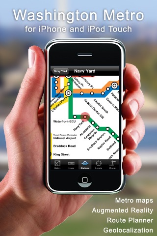
Washington Metro app for iPhone and iPad
4.9 (
4729 ratings )
Travel
Navigation
Developer:
Presselite
0.99 USD
Current version:
3.1.1, last update: 7 years ago
First release : 19 Jan 2009
App size: 1.36 Mb
************************************************************
AUGMENTED REALITY
************************************************************
Washington Metro Your New Eye. This is a unique augmented reality functionality (only available to iOS4 users with an iPhone 3GS or iPhone 4) that enables you to see the nearest stations and POI with iPhones camera live view. Elements located at a distance less than 1km (0,621miles) only will be displayed.
- iPhone vertical position: 360-degree view of all stations nearby your location, updated in real time as you walk in the streets.
- iPhone horizontal position: List of all nearest stations. When a station is selected, a red arrow (compass) is displayed to show the direction and the distance to that point.
************************************************************
DESCRIPTION
************************************************************
Washington Metro iPhone and iPod Touch application is a comprehensive guide to traveling through Washington, DC. It includes subway maps.
- Detailed map of Washington subway. Landscape and portrait modes are available.
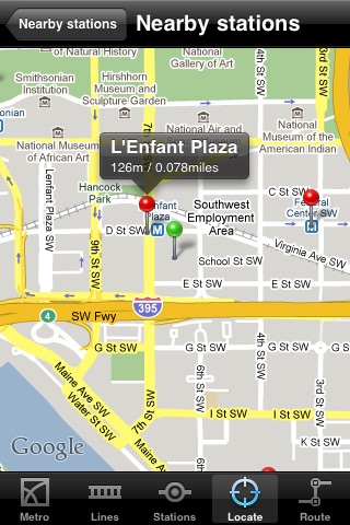
- Precise location of each station on the map (with a red circle). This application is fully compatible with Google Maps, each station is represented by a red pin, a popup shows you the distance, and its updated live (thanks to GPS) as you walk in the streets of Washington.
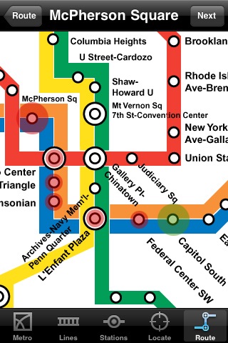
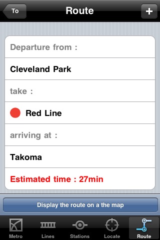
- The journey planner tool allows you to find automatically the best route to get to your destination in Washington Metro. Interactive map to choose your stations for the route. To get better Route results, please switch into Best Route in the settings. The journey planner does not require a network connection to operate, it works perfectly while in the subway.
- A bookmark manager allows you to save your favorite stations and routes.
- The application locates the nearest metro stations from your position in Washington. You can also provide an address in Washington, the application indicates the stations closest to that address.
- Service Advisories (Live travel news) from Washington Metropolitan Area Transit Authority is available.
- You can add new Point of Interest (POI) databases to Washington Metro application through an in-app purchase. These options allow you to activate Fast Food POI, Restaurants POI, Coffee, Pastry & Ice Cream POI, Leisure POI and Accommodation POI in Washington. You will be able to locate all nearby POI on Google Maps.
- This application is available in English, French, Spanish, German and Japanese.
Thank you for taking the time to report any bugs or to request an enhancement to Washington Metro application. Feedback is very important to us. We will do our best to answer queries. Email us at [email protected]
Pros and cons of Washington Metro app for iPhone and iPad
Washington Metro app good for
Well done app with lots of options for navigating the DC metro. Navigate by route map, "linear" map or station name. Also provides routing guide to transfer between lines to reach destination. Clever use of GPS function to locate nearest station. No crashes for me.
Nice app, but would be a 5 star if it was updated to include station information to include operating hours, parking, etc.
I have iTrans DC, but prefer this app. Nicely done with a variety of options for finding your route. Updated to include service advisories, developer is responsive to feature requests. If they can add real-time arrival info, Ill give it 6 stars!
Love it! Just what Ive been looking for! Keep up the good work! Id love to see TIME updates. Thank You!
Though I have lived near Washington for years, I recently bought this in preparation for a trip to NYC. It made my life infinitely easier, as I was traveling with a child, and did not want to have to get up to check a map. I could time my trips better, double check routes, and explain where we were going to my son. Lots of apps have bells and whistles, but this one is actually useful.
This app is very useful. The only thing I dont like about it now is the map from the new update. could the makers please change the map back? I cant find what stop is closest to Georgetown and I dont know where the stops are geographacly. Thanks. otherwise this app is great.
Some bad moments
not good. seems like an old app that doesnt work properly on newest iOS version and locks up. Free apps are better
This crashed my phone more than half the time. Its looks like it would be a great app if it actually worked.
If you already have an understanding of the DC Metro system, meaning you know where to enter and exit, this app is no better than a paper map you can get for free at any Metro stop. You search for the Metro stops that you want to use and this app simply tells you the route. Would be worth the price if the user could input starting and ending addresses (door to door) and the app gives the stops to use and the walking route, if needed. Better off using the WMATA mobile site (which is free), it gives you every thing this app has to offer, plus a real "door to door" trip planner.
I was very disappointed in this app. As an iTouch user I have to rely on local WiFi to do any browsing so the only features on this I could use IN a station were viewing the system map, and planning my route. Which wouldve been fine, IF planning a route through this app included train/bus schedules. But it doesnt. In fact, you need to know which station you want to go to, an address wont even compute. And it seems as though busses dont even exist to this app...
I thought this was a cool app to have POIs, but what is not very clear in the discription is that you pay a fee for ****EACH**** POI you want to have on your map!!!! Had I known, I would have never purchased this app! What a ripoff!!!!
very disappointing. unable to find nearest station relative to my current location or input address! what exactly is the point of this if I cant figure out a way to get from point A to point B on the metro? did I just pay 99cents for an image of the lines?